![]()
![]()
![]()
![]()
![]()
![]()
![]()
![]()
![]()
![]()
![]()
![]()
![]()
![]()
![]()
![]()
Marooned
in the Bluegrass
Written
September 3, 2019
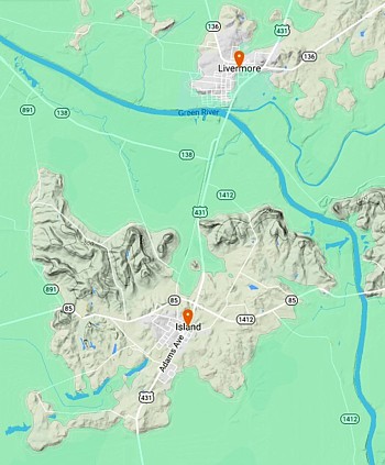
The Green River wanders for 384 miles through western Kentucky before reaching the Ohio River near Evansville, Indiana. Three-quarters of the way through its course, the Green is joined by a muddier stream, the Rough River.
|
That confluence takes place at the red dot on this map. The locals call it the Point, and next to it, in the town of Livermore, my father was born in 1909. |
|

He left Kentucky at the age of 28 and started a little family in Ohio. But whenever we went back to visit his relatives, we'd take a trip out into the country. Over the river and through the woods, to one cousin's farm we'd go. Our car knew the way.
Island Hopping
|
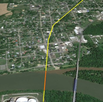
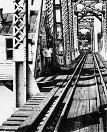
In the first little town past the river, we'd turn right on Main Street. Then we'd point the nose of our Oldsmobile skyward. We had to scale a scary wooden bridge over the railroad track. |
|
|
Those rails are gone now, but the bridge has been preserved and relocated to a park in the next block. |
|


The town is called “Island.” I always wondered why. It's not out in the middle of the river; it's three miles away, on dry land, surrounded by hills and fields. But in those days I couldn't look things up on the Internet. Now I can.
One of the first local settlers was William Worthington, who had fought in the American Revolution under George Rogers Clark and then moved from Virginia to Kentucky in 1784.
|
In springtime, the rivers sometimes overflowed and inundated their surroundings. Here I've shaded in green the areas below 400 feet in elevation. Knowing better than to build on a flood plain, Worthington settled on eight square miles of high ground. Because he was occasionally marooned when his estate was surrounded by water, the place became known as The Island. |
|
|
|
Later, in 1872, the Owensboro and Russellville Railroad arrived. They built a small depot which they called Island Station. Before long, the name of the local post office had become simply Island. To avoid climbing all the way up the hill, the rails had been laid a little below grade level, so the O&R built that wooden bridge to enable local folks to cross the tracks. |

River Hopping
The O&R built another bridge that year, one that they undoubtedly considered more important. It carried the railroad across the river at Livermore.
|
The tracks aren't there any more, but their route ran like this. US 431 was later built a few hundred yards to the east. Where did Livermore get its name, you ask? Further Internet research reveals it was named in honor of a Pennsylvanian. Alonzo Livermore was one of the nation's best-known civil engineers. |
|
He had been the chief engineer of the Pennsylvania Canal, completed in 1834. The next year he was hired to come to Kentucky, where the Green River was being “canalized” to allow navigation as far inland as Bowling Green. This was the first improvement of its kind in the United States.
|
A three-year project had already begun to build Lock and Dam No. 2. Mr. Livermore redesigned the lock chamber to make it 160 feet long by 36 feet wide. This was eight miles below the town that would later bear his name. |
|

But we were about to discuss the 1872 railroad bridge at Livermore. Although it was an iron bridge, it wasn't particularly sturdy. I speculate it was built rather high and spindly so that steamboats with their smokestacks could pass underneath it.
Swing that Span
|
|
By 1908, the Louisville and Nashville Railroad had acquired the former O&R. However, their heavy new locomotives couldn't cross the 36-year-old bridge. They had to tear it down and replace it with a stronger structure. |

River traffic was temporarily halted on August 3. Because the interruption to navigation could last no more than 28 days according to government regulations, the L&N put two shifts of workers on the job.
|
According to a local newspaper, “All the boats which navigate Green River as far up as Livermore are forced to transfer their passengers and freight at that point to another boat. “The Bowling Green and Evansville Packet Company have placed one of their boats above the bridge and one below, and they make connections at that place so as not to cause so much inconvenience to the passengers. |
|

“If one of the boats reaches Livermore before the other, it has to wait until the other boat reaches that port.
“The trains do not have to transfer their passengers and freight as yet, but the officials of the road think that they will have to begin to transfer from one train to another at a very early date. When they do begin to transfer the freight, several barges and boats will be employed.”
|
And here's the structure that was completed that autumn, with mast-like structures atop the trusses. The bridge stood less than 30 feet above the water. During flood season, there was even less clearance. |
|
|
Kids could play beneath the rumbling trains, as in this old photo from the Owensboro Messenger and Inquirer. But was there room for tall boats to pass? |
|
|
In April 1956, I photographed a ferry crossing the mouth of the Rough River. In the background, you see the railroad bridge with its center span resting upon a wide stone pier. It actually rotated on that pier! |
|
|
I assume that when the bridge was to be opened, the masts would be lowered to halt the trains, as indicated by the dashed lines I've added to this 1915-era photo. |
|


|
Bridge tender George Russell, pictured in the Messenger and Inquirer keeping watch from his little house in the middle of the span, said it was “almost like walking guard in the Army.” He had to look all four ways to watch for oncoming boats and locomotives. When necessary, he'd signal a warning to the L&N and then swing the span 90°. Then, with the obstruction out of the way, a boat could pass on the left or on the right of the central pier. |
|
|
The boat's crew had to steer carefully. There was a massive stone pier right in the middle of the river! To protect it from barge collisions, upstream and downstream bumpers were added in later years. |
|

As time passed, railroads slowly became less profitable. Freight service over this route ended in 1984. The tracks were removed, and the bridge was dismantled in 1988.
However, you can still visit Livermore Riverfront Park and climb atop one of the old piers. Called the Two Rivers Historic Overlook, it gives a good view of the Point. (Notice the brown water from the Rough reluctantly mixing with the green water from the Green.)
|
|
|
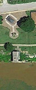

George Russell's big pier out in the middle of the stream? It's not there any more.
|
|
|
